AI Data Centers

AI Data Center Satellite Explorer

Scrub the timeline to watch the campus get built out. Each capture pairs an aerial image with the standardized capacity status on that date.

Sweetwater 2 IREN Limited IREN Texas, USA
Full site details →

Construction status

Imagery

Satellite Explorer is a Pro feature

Scrub dated satellite timelines of every covered AI data center campus, paired with the disclosed capacity status on each date. Included with Ziven Professional and API memberships.

Upgrade to Pro

Watch a campus get built: IREN Childress, Texas

Drag the slider to wipe between two dated satellite captures — open Texas ranchland in August 2020 becomes a hyperscale AI data center campus by July 2025. Ziven Professional and API members can scrub the full dated timeline like this for every covered site, and compare any two captures side by side with the disclosed capacity status on each date.
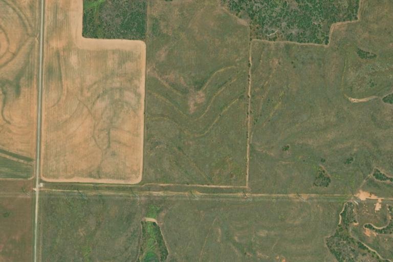
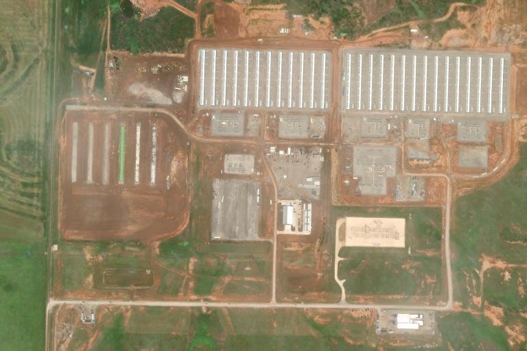
Satellite view of the IREN Childress site in August 2020: open ranchland before construction Satellite view of the IREN Childress campus in July 2025: completed data center buildings

In development: know what every building is

We're mapping the structures on every covered campus — data halls, substations, staging yards — along with the date each one first appears on satellite. Here's an illustrative preview on the July 2025 Childress capture:

July 2025 satellite view of the IREN Childress campus with example building annotations Data halls Substation Laydown & staging

Satellite View of AI Data Center Construction

The Satellite Explorer pairs dated satellite imagery with Ziven's standardized capacity data, so you can watch an AI data center campus get built over time. Pick a site, scrub the timeline, and each capture shows the facility as it looked on that date alongside its energized, under-development, and pipeline megawatts. Imagery comes from dated archives, primarily the Esri World Imagery Wayback basemap, with USDA NAIP aerial captures and licensed imagery for some sites and dates; capacity figures come from the same sourced dataset that powers the AI data centers page and each site's capacity history. Timelines are offered for sites with confirmed precise coordinates, from hyperscale campuses rising in Texas to converted Bitcoin mining facilities, so the construction progress you see always matches the disclosed numbers on that date. The Satellite Explorer is included with Ziven Professional and API memberships.

Sites with satellite timelines

Open the Satellite Explorer, pick a covered site, and scrub the timeline. Each capture is a dated, archived aerial or satellite view of the campus, so stepping through the captures shows land clearing, building shells, and new data halls appearing over time, alongside the site's capacity status on that date.

The explorer covers AI data center campuses operated by publicly traded companies tracked on Ziven — from hyperscale campuses rising in Texas and North Dakota to converted Bitcoin mining facilities — including sites operated by IREN, Applied Digital, Core Scientific, Cipher Mining, Riot Platforms, TeraWulf, and Hut 8. Coverage grows as more sites gain confirmed precise coordinates.

Primarily from the Esri World Imagery Wayback archive, which preserves dated versions of the world imagery basemap, supplemented by USDA NAIP aerial captures and licensed high-resolution imagery for some sites and dates. Ziven pairs each archived capture with the site's standardized capacity data on that date; the imagery itself is not modified.

Whenever the underlying archives publish new captures. Esri releases new World Imagery Wayback versions throughout the year, USDA NAIP flies each state on a rotating survey cycle, and licensed high-resolution captures are added for selected sites. Every capture is dated, so the timeline always shows when a view was actually acquired.

Timelines are only offered for sites with confirmed precise coordinates. When a company disclosure only supports a city or town centroid, the explorer would show the wrong patch of ground, so those sites are left out until the exact location is verified.

The Satellite Explorer is a premium feature included with Ziven's Professional and API memberships. Subscribers can scrub the full construction timeline of every covered site; without a subscription the page shows a locked preview. Plans are compared on the Ziven pricing page.
